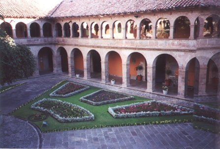
This is part of the inner courtyard of the hotel Monestario,
showing the first and second floors, and the gardens in the center.
Day 5: Cuzco, and a day trip through the Sacred Valley of the Incas
This day got off to an early start. We checked out of the hotel (waking up the desk clerk to do so) in the wee hours of the morning, and our guide and driver took us to the Lima airport for our 4:30am check-in for the 6am flight to Cuzco. It was good that we arrived early, as the ticketing computers were not working, and the boarding passes and luggage check-in had to be done by hand. What could have been a frustrating and nerve-wracking experience was made much easier by the fact that we had arrived early, and that we had a Spanish-speaking professional guide to help us deal with the airport personnel at each step of the way.
The flight to Cuzco was relatively short, and when we arrived it was now daylight outside. After collecting our luggage we were met by the next guide, who was holding up the usual placard with our names on it. We were driven to our hotel, the five-star Hotel Monestario, which was a converted Spanish monestary. One of best hotels in Cuzco, it is obviously not a modern hotel, but one with plenty of history and old world charm. We were given a traditional welcome cup of coca tea (made from the coca bush, from which cocaine is also derived), as this tea is good for helping people acclimate to the high altitudes of Cuzco (approx. 11,000 feet).
This is part of the inner courtyard of the hotel Monestario,
showing the first and second floors, and the gardens in the center.
After a brief stop in our hotel room we met the guide and driver to begin our full day excursion to the Sacred Valley of the Incas. The trip itself takes several hours, plus the time spent at the two Inca ruins sites, and the market at Pisac. The road winds through the hills above the valley floor (which is taken up with farm land and the Urubamba River), and the views and sights are wonderful.
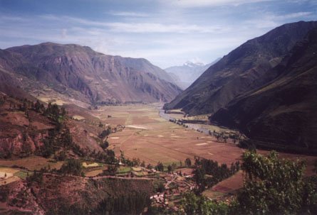
The sacred valley of the Incas
The photo above was taken from a stop at a scenic lookout at one point on the road. You can see the river to the right of the farmland, and in the foreground is one of many small villages that we saw during the day. In the far distance you can see a snow-capped peak of the Andes mountains. It must have been a popular stopping point for the tourist guides, as a number of local indians had set up blankets covered with souvenirs to sell to the tourists that stopped there.
The first most important stop on the trip was to the Inca ruins of Pisac. One of the factors that helped me decide on the selection of our particular tour company (Lost World Adventures) was that they were one of the few companies that went to the ruins of Pisac, whereas most travel companies merely go to the marketplace in the modern town of Pisac. I was more interested in ancient ruins than marketplaces, though, so I made a special point of making sure that we would be going to the ruins on this part of the trip.
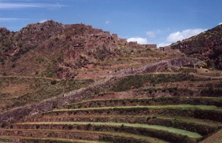
First view of the ruins of Pisac from below. The ruins are near
the top of the mountain in the center background of the photo. In the foreground you can
see terraces used by the Inca farmers.
The hike up to the ruins wasn't overly difficult, but due to the high altitude (over 11,000 feet) you had to pace yourself and not set an aggressive pace (especially since it was during our first hours at this height, so we hadn't had a chance to acclimatize ourselves yet). You also had to pay attention to what you were doing, since the winding footpath was on the edge of cliffs (with no guardrails), and it was a long way down if you slipped. As we usually did, I took camcorder footage while Sue took the 35mm still shots. We saw two or three sections of ruins at Pisac, and then headed back for the mini-bus. I had seen signs saying "'Inti-huatana' this way", but for some stupid reason I had failed to ask the guide about it. It wasn't until later that day that I saw a postcard of Pisac, which showed the buildings at the top of the mountain, which we hadn't hiked to. It was the buildings at the top which were known for their quality, having been compared to the finest Inca stonework at Machu Picchu. I would have liked to have seen those upper structures, but, oh well. The lesson is this: if you go all the way to visit Pisac, make sure you take the extra time to go all the way to the top of the ruins.
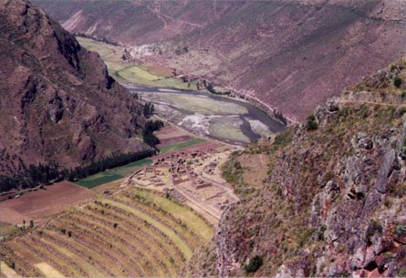
From the ruins of Pisac, looking down into the valley in the
opposite direction. You can see the winding Urubamba River on the valley floor in the
center of the photo. More terraces are visible in the bottom left corner.
After leaving the ruins of Pisac we went to the "modern" town of Pisac. (It's not modern in the way a city in the United States is modern, but is actually a typical Andean town containing a unique blend of ancient Inca, Spanish Colonial, and somewhat modern characteristics.) The main attraction in the town of Pisac (at least from a tourist perspective) is the marketplace. Local people go here to buy and trade food and other necessities, and tourists go here to buy sweaters, weavings, carvings, and other souvenirs. Our guide walked with us while we wound our way through the labyrinth of stalls, occasionally checking out or buying small items of interest. I bought postcards, a videotape of Inca sites (in case something happened to my camcorder tapes), and a few nick-nacks. I also spent a while bargaining for a baby alpaca wool poncho for a friend back home. Having gotten the price down to $75 (from the original $100), we finished up our time at the market (which was somewhat limited, because we had more places to go to that day). Before we left we sampled some locally baked hot bread items that were kind of like pita pockets.
The next stop was an weaving factory/store that specialized in alpaca hair items (there were even a few bored alpacas laying down outside the front door). We bought a couple of sweaters (it's hard not to come to Peru and not get an alpaca hair sweater). The store also had a mini refreshment bar and restrooms, both of which were welcome at this point in the trip.
We headed off down the valley, and at some point stopped at a place that I think was a restored Spanish colonial-style mission, which had been converted into a hotel. Tourists came here mostly for the outdoor buffet lunch, which was very good. There was a variety of dishes here, the most unusual one being the alpaca meat. It was white, like pork, but had a taste kinda like beef, though different. I wouldn't order it again, given other choices, but it wasn't bad, and had to be tried as a part of the whole vacation experience.
After lunch we drove on to the northwestern corner of the valley, where we came to the town of Ollantaytambo. At the edge of town, against the rising mountains, were the Inca ruins of Ollantaytambo. Our driver parked the mini-van amid the plethora of tourist buses and our guide took us up into the ruins.
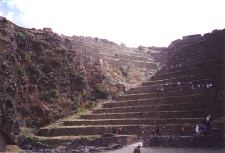
First view of the Inca fortress of Ollantaytambo. The farming
terraces (covered with tourists) are on the right, and the ruins are in the back center.
We hiked up through the old Inca terraces towards the top where the fortress lay. The climb seemed more arduous than you expect, due to the high altitude, which made any physical exertion even more difficult.
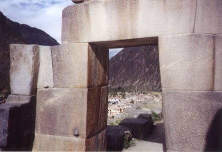
Fine example of a trapezoidal doorway at Ollantaytambo. Note the
excellent workmanship, resulting in junctures between the stones that are so tight that
you can't fit a piece of paper between them. The knobs protruding from some of the stones
were for propping the stone up while it was being lowered into place; these knobs would be
removed and smoothed over once the work was done, which is evidence that this site was not
completed before the Spanish arrived. The modern town of Ollantaytambo is just outside the
ruins, and some of it can be seen through the doorway.
The fortress of Ollantaytambo contains some very interesting stonework. There are some massive blocks fitted together with incredible precision, and a variety of other architectural features that are too hard to describe in this limited forum. Suffice to say that if you really studied the construction techniques at this site you would be amazed at what the Incas had accomplished with their supposedly "primitive" tools. Even the effort to bring the huge stones down from the opposite mountain miles away (and then back up to this mountain top) was an incredible feat in itself.
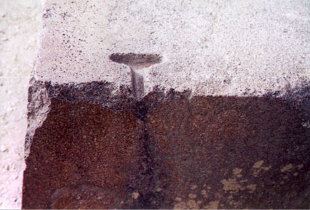
A close-up of the edge of a large stone block at Ollantaytambo.
Of interest is the T-shaped clamp hole (about 4" across), which was designed to hold
a metal clamp/staple. The block that would have fitted up against this block would have a
mirror-image clamp hole, so that when the two stones were together a metal bar (shaped
like the capital letter "I") would be put into the indentation, helping to keep
the stones together during the somewhat frequent earthquakes. We saw similar clamp holes
at Tiwanaku in Bolivia, and had previously seen them at the temple of Dendera in Egypt
(though the Egyptians supposedly used wooden clamps).
We completed our visit to the upper fortress, and then explored some of the structures at ground level. I found some pieces of ceramic pottery amidst the many small stones covering the dirt pathways. Our guide said that the pieces that were a little over a quarter of an inch thick were genuine Inca pottery pieces, whereas the thinner fragments dated to more modern times. We were allowed to take the Inca pieces with us, since they were of no use to anyone, and there were plenty more to be found scattered around the site.
Heading back towards Cuzco, we took Highway 108 southward, arriving in the late afternoon at the town of Chinchero. There used to be Inca ruins at Chinchero, but from what I could see all that remained was one large wall that had a number of trapezoidal niches in it. A Spanish colonial-vintage church dominated the site, but the main focal point for the tourists was the square courtyard which had a bazaar for tourist souvenirs. There was a small museum next to the courtyard (no photos allowed inside), but it didn't contain a lot of interesting items.

This is the marketplace at Cinchero. The locals have set up
their blankets with goods to sell to the tourists around the central square, and in the
background you can see what remains of the original Inca wall (the tan wall with
trapezoidal niches), with the colonial Spanish church farther back in the background.
Sue found a sweater that she liked at one of the vendors, but it was in the wrong size. The Quechua girl said "wait a minute...", and ran off. We waited and waited, and had almost given up, beginning our walk back to the van. She luckily found us before we left, as she came up to us all out of breath, with the sweater in the correct size. She had run all the way to her home in town to get the sweater for us. After such a great effort Sue was willing to pay the (now inflated) asking price, and we completed the transaction and departed.
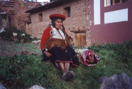
A local Quechua (descendent of the ancient Inca) woman, posing
with a baby lamb on her lap. Around most of the tourist sites it is fairly common to see
one or more of the local indigenous people dressed up in traditional Inca garb and posing
for photographs for the tourists (in exchange for a one sole coin, worth about 35 cents).
They usually add a cute animal to the mix (llamas, typically) to help intice the tourists
into wanting to take their picture.
On the way back to Cuzco we stopped at a scenic lookout point to take a photo. There was no one else there, except a group of local children, who seemed surprised to see us there. We gave each of the kids a colored pen as a parting gift (I had brought about twenty such pens on this trip to use for such occasions). As the light faded from the sky we continued back to our hotel, arriving in Cuzco after nightfall.