THE EARTH IN A PRECATACLYSMIC SITUATION
This civilization was conveniently
organized. In the large concentrations of people which I have called Megapoli
the intelligent and scientific men were found, and they assigned to the
continents and their respective compartments specific functions. Agricultural,
technical and industrial labor was left to the charge of other men, each doing
the type of work for which he had been trained. A rational distribution has been
observed in the use of the continents, and it has been seen that certain zones
are not cultivated, possibly to allow for the regeneration of the fertility of
the soil, while other zones are used for agriculture, animal breeding and
industry. All this, and the fact that people appear to be gathered in areas of
large concentration, make it certain that the intention of these two stone is to
point to the coordinated use of the natural resources of the planet to achieve
an equilibrium in its metabolism. I say that there is only the intention of
pointing to such a balance because I believe that if such a harmony had been
achieved by the gliptolithic humanity it is evident that it did not exist on
earth if one takes into account the situation of progressive heating that the
planet was experiencing according to the symbols on the stones. It is to be
remembered that there are no polar ice-caps drawn on the maps of the continents,
and that the mass of water is very small in comparison to the size of the
continents. This would indicate a lack of harmony in the metabolic system of the
planet. By this situation I see that something abnormal must have occurred
between the time when the natural resources of the planet were distributed
harmoniously and the tine depicted on the stones. This must have been same
departure from the main pursuit of the evolution of the human race, which, as I
have previously stated, was the development of the intellect in order to
increase and conserve knowledge.
The critical situation of the planet's
metabolism according to the symbols on the two stones consists of the saturation
of the atmosphere with large amounts of water vapor. If the proportion of water
to continental mass shown on the stones is compared to that which exists on
earth today, it will be noted that the ancient planet had one part of water to
every four parts of continental mass while our present day earth has four parts
of water to every one part of continental mass. We can thus see that the planet
represented in the stones was at that time a closed thermic system. It received
thermic energy from sun, but it could not radiate it back out because of the
enormous cap of vapor (a sort of black body formed by the clouds) that
surrounded the planet. This thermic disequilibrium should have led to a critical
point at which the water vapor precipitated in the form of an unending rain that
released a correspondingly large amount of mechanical energy that resulted in
the beginning of the shift of the enormous continental masses; that is, a
cataclysm of monstrous proportions.
If one accepts that fact, confirmed by
contemporary science, that the continents on our planet are moving at a speed of
six centimeters per year, it is not strange to think that the planet, presented
in a precataclysmic state on the stones, represents the earth and that the
cataclysm that was imminent finally occurred, causing the continents to shift
violently, so that the six centimeters we observe today are only the residual
movement of a much more violent shift earlier in history. This theory becomes
more plausible when we compare the distribution of the continents and seas of
the planet represented on the gliptoliths with their distribution on the earth
today. Further, if we shift
Europe
and the northern part of Africa towards the west, and the continent of Asia to
the east we can see how the theory becomes more plausible. By doing this we can
reconstruct 90 percent of the planet represented on the two stones (see the
diagram that reconstructs the ancient position of the continents on earth).
Contemporary culture has received,
through written tradition (Myths, legends, historical, etc. universally referred
to), an image of what the past of our culture was like, (though it may be
incomplete and disarticulated). Thus, the people of the earth spoke of a
cataclysm in the remote past. For some people the cause of the cataclysm was the
rain of giant asteroids from the sky, for others the fall of supposed satellites
that the earth had. For still others the cataclysm consisted of a universal
flood. The science of geology itself speaks of a cataclysm as a result of the
rising up of the mountains and of volcanic eruptions all over the globe, (the
Andes, the Rocky Mountains, the Alps, the Himalayas, etc.), called the
revolution of the mountains, which apparently occurred at the end of the
Cretaceous period (70 million years ago), in the Mesozoic age.
All this confirms that the
precataclysmic situation symbolically represented in the two gliptoliths
corresponds to the period before the cataclysm that occurred on earth in the
distant past.
HOW THE CONTEMPORARY CONTINENTS CAME TO BE
The fact that this cataclysm
occurred that caused the continents to shift allows me to reconstruct the paths
of the different continents as they shifted. In addition it permits me to
reconstruct the situation under which the continental masses were formed. All
this develops from the location of the continents in the distant past, as drawn
on two gliptoliths.
It is necessary to keep in mind that
the earth was inhabited by man even before the great cataclysm occurred, as is
attested to in the hemispheres of the gliptoliths.
ANCIENT
AMERICA
Contemporary geology has confirmed
that at the end of the Cretaceous period the continent of
America
was divided into two parts, North and South, with no union between the two.
Paleontology has confirmed this fact by revealing that fossils found on both
these land masses are similar only from the beginning of the Tertiary period
(some 63 million years ago), a little after the tine at which geologists confirm
the formation of a bridge between the two continental masses. The animal fossils
found, (the remains of the prehistoric armadillo and the giant saber tooth
tiger), had as a common habitat North and
South America
as a result of the formation of a bridge between the two continents that in its
turn resulted from the terrestrial cataclysm. If the shape of the ancient
continent of America that is postulated by geologists to have existed is
compared to the shape found on the gliptolith, it will be found that this shape
corresponds to blocks A and C of the first hemispheres (Fig. 59), block A being
North America and block C being South America. This geographic coincidence leads
us to reaffirm the existence of man (gliptolithic man) in the distant past.
Findings of human bones associated with those of extinct animals also confirm
this possibility. The English colonel James Churchward found sacred tablets in a
temple in Tibet which he was able to decipher. These tablets told the story of
the ancient world with maps of the terrestrial hemispheres as they appeared at
that time. Here the American continent was also divided into two distinct
blocks, North and South. At the beginning of this century, the English
archaeologist William Niven found petroglyphs in Yucatan, Mexico, that once more
show a divided American continent, thus verifying Churchward's find in India.
Quechua (South American Indian)
legends speak of the existence of the navel of the world, that is, the center of
a mysterious and ancient culture that must have lived in the
Cusco area of
Peru. It
is to be remembered that in this area there are huge stone constructions such as
Machu Picchu, Sacsayhuaman, Ollantaytambo, etc., whose technology is surprising
to contemporary scientists because it is as yet unknown to them. In relation to
a descendant of the Incas, the history of Peru has a name, Tupac Amaru, that was
given to a man who lead a rebellion in Cusco at the end of the eighteenth
century against the Spaniards. This same name was given centuries earlier to
another descendant of the Incas. It is thus possible that this name may come
from even further back in time, from a remote past, because if the significance
of the two words that make up the name is examined a correspondence is found
with situations that occurred long before the age of the Incas. In Quechua, the
name means "hunter of serpents", "amaru" being the name for serpent. Initially
one might think of the serpent that is known today. But it is worth remembering
here what was said in Chapter I of this book about the biological cycle of the
dinosaur: these were seen to have passed from a larvaic stage in which they
appeared much like serpents. A dinosaur of the lambeosaurius species, described
by paleontologists, has the same morphological characteristics as those of a
monster described in the Quechua legend that has been transmitted orally for
centuries, and that refers to the fact that this monster terrorized the "first
human beings". The legend says that this was a horrible monster, with the head
of a llama, the body of a Batrachia, the fins of a fish, and the tail of a
reptile that lived on the depths of a lake (39). Paleontologists reconstruction
of the Lambeosaurius from fossils is not only similar to the morphology of the
monster described in the legend, but also reveals that its habitat is that of
lakes, where it fed on decomposed organic material. Since the hunter indicated
by the word "Tupac" can be no other than a man, the legend signifies in the
final instance that both man and dinosaur coexisted in South America. And,
although scientists have always discounted such a coexistence without just
reason, the findings of the Colombian anthropologist Homero Henao Marin have
demonstrated that this coexistence was a fact, as I have mentioned in Chapter I.
ATLANTIS
AND MU
DID NOT SINK
Through the affirmations of the Greek
philosopher Plato it has come to be known that there once existed a continent
called Atlantis that sank into the
Atlantic ocean
after the occurrence of a cataclysm. The map of the terrestrial hemispheres
found by James Churchward on the sacred tablets in Tibet show an unknown
continent on each side of the ancient continent that was to become present day
America. One of these continents was in the
Atlantic,
and the other in the Pacific, and they were, respectively, the continents of
Atlantis and the continent of Mu. The legends and traditions of the inhabitants
of the Pacific Islands speak of the fact that these islands were part of a large
continent that was destroyed by a cataclysm. These continents are also present
in the petroglyphs that William Niven in Yucatan. The testimony of Plato,
Churchward and Niven coincide with that which appears on the first hemisphere of
the gliptolith that I have described. In this hemisphere block B corresponds to
the continent of Mu and block D to the continent of Atlantis (Fig.
59). Despite the fact that it is believed that these two continents
disappeared, based on the imaginary shift that I have devised of the
contemporary continental masses to demonstrate that their ancient position is
that which is shown on the gliptoliths, I think that the continents of Mu and
Atlantis shifted without disappearing, in opposite directions towards the other
hemisphere, and that they collided with the other continents that already
existed there. Thus, the continent of Mu came to form a large part of the
continent of Asia and the Pacific Islands (Easter, Tahiti, Samoa, Lele, Hawaii,
etc.), while Atlantis came to form part of Europe and the Northern part of
Africa and the Atlantic Islands, such as the Azores, Madeira, and the Canary
Islands.
Geologists have found that the
geological caps that make up the Ural Mountains (dividing European Russia from
Asian Russia), are not uniform. This allows us to speculate as to the
possibility that here is where the collision between the two continental masses
might have taken place, confirming that
Europe and
Asia
are parts of Atlantis and Mu respectively.
THE CONTINENT OF LEMURIA
Research in the nineteenth century by
Ernst Haeckel indicate that in some distant past there existed a continent
called Lemuria, which he places between the archipelago of Malaysia (the eastern
extreme of Asia) and the island of Madagascar (on the Western coast of Africa).
The name of Lemuria comes from the fact that according to Haeckel the continent
was inhabited by lemures (notharctus) that were very intelligent. This led
Haeckel to believe that the continent was the cradle of the humanity.
These considerations are confirmed by
the second gliptolithic hemisphere (Fig. 60), since
in what I have called block G there appears a figure of a notharctus (12 in
Fig. 60). This allows me to deduce that this block
corresponds to the continent of Lemuria. Due to the shift of the continents,
Lemuria must have moved south, being displaced by the continent of Mu. Lemuria
came to form part of what is now
India.
There are references from ancient time
- corroborated by the findings in recent decades by explorers and mountain
climbers - of the existence of a large anthropomorphic being in the region of
the
Himalayas
called the Yeti or "abominable snowman". This enigmatic being who has revealed
itself only in the form of footprints, could be a descendant of one of the
humanoids of the gliptolithic humanity, possibly in a regressive stage,
returning to the level of an animal, that is, to the level of the notharctus
from which the humanoid was originally created. By contrast, the existence in
this region of men dedicated entirely to meditation would indicate the survival
of that constant practice of the gliptolithic humanity: to develop the
reflective capacity to increase and store knowledge. The gliptolithic humanity
having disappeared, the constant meditation to which some men in this region
devote themselves is another example of the incomplete legacy of the
gliptolithic humanity. It is not impossible, however, that some of these men may
have reached very high levels of cognitive and intellectual ability.
AUSTRALIA AND ANCIENT AFRICA
Due to the shift of the continents,
block E descended (E’ in Fig. 60) to form, in its northern part, southeastern
Europe, and in its southern part, Anterior Asia. Added to this decent, that
bridge of territory that united block E’ with block E" was fractured, so that
E', in its decent, was united with block F (F in Fig. 60). Block F, in its turn
connected itself in the north to a section that had come loose from Atlantis to
form the south of Africa (remember that a large part of Atlantis went to form
Europe,
as I have mentioned). The notable differences between the north and the south of
the African continent have always been an enigma, even to the extent that they
seem to be two distinct continents. In the north there are remains of advanced
ancient civilizations; these do not exist in the south. Between the two extremes
there are also ethnic differences and differences in the flora, fauna, and the
geological makeup of the soil. From a geological point of view, it has been
found that the geological caps of the
Atlas mountains
are not uniform, as if in this spot two continental masses had collided. Block
E", (Block E" in Fig. 60), separated from block E', came to be Australia
(geologists have proved that this continent has been isolated from the rest of
the world since the end of the Mesozoic era). The territorial bridge, broken in
many segments, was dispersed and formed islands, some of which, like Madagascar,
ended up near the coast of Africa, in the Indian Ocean, (this explains why the
structure of the geological layers of soil on this island is so different from
that of Africa). Other islands, such as the Malaysian archipelago also followed
the same pattern, but became more scattered.
Geologists have been surprised to
find similar geological structures of subsoils very far apart. This is the case
of the carbon subsoil (corresponding to the fifth period, some 345 million years
ago, during the Paleozoic age) that make up the earth's crust in southeastern
Europe and the island of Sumatra (that is part of the Malaysia archipelago in
southeast Asia). The distance between these two areas confirms the theory of the
shift of the continents from their original position as revealed in the second
gliptolithic hemisphere. The carbon subsoil found in the southeast of
Europe
evidently was part of the northern half of block E', and that of Sumatra is one
of the islands that resulted from disintegration of the land bridge between
block E’ and block E".
Classic archaeology has not been
able to explain the finding of instruments that reveal very advanced scientific
and technical knowledge in the distant past. Such is the case, for example, of
certain synthetic fibers that are similar to those made today and that have been
found in Chinese burial grounds. Russian archaeologists have found magnifying
glasses in Egypt, the grinding of which can only be achieved with cerium oxide,
a chemical that can only be produced through electrolysis, a fairly recent
discovery. Similar lenses have been found in
Iraq
and in Australia. In the museum of Bhagdad among the rare objects, one can find
extremely ancient electrical batteries in working order. Perhaps the most
astounding find, however, is that of an atomic power battery found in Gabon,
Africa, that ceased to function more that one hundred million years ago.
THE ROCKS WERE SOFTENED
Just as these two gliptoliths reveal
information about an organized system of life that was attained by man on Earth,
I have also said that they reveal the existence of a precataclysmic situation
which the planet faced in this distant past. The intense and increasing heat
which created this precataclysmic situation must have also caused the rocky
surface of the planet to soften. Throughout my research I have found testimony
to this specific softening of the Earth's crust.
In the rock ground of the ruins of
Quenco (Cusco,
Peru) there are remains of the "intihuatana" or solar clock whose invention is
erroneously attributed to the Incas. This clock kept track of the years and the
seasons. It was made up of a central column - an equinoctal column - and four
pairs of lateral columns - solistical columns. Only fragments of the solistical
columns remain, as well as the stone table on which the central or equinoctal
column stood (Fig. 69). Its destruction is evidence
of a cataclysm more than the effects of the Spanish conquest or the tyranny of
time.
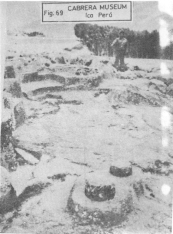
FIGURE 69: The remains of the
INTIHUATANA solar clock in Quenco. Observe the stone fragments of the solistical
columns and the stone table
(pointed out by the man in the photograph) over which the equinoctal column
stood. Its destruction is evidence of the action of the cataclysm.
On the same rock ground at Quenco, near
to the "intihuatana", one can clearly see the print of some sort of shoe; of
normal proportions, and next to it the print of an unidentified animal (Fig.
70). These footprints could only have been made in a very distant past in
which the rock was softened by the intense heat and humidity of the planet.
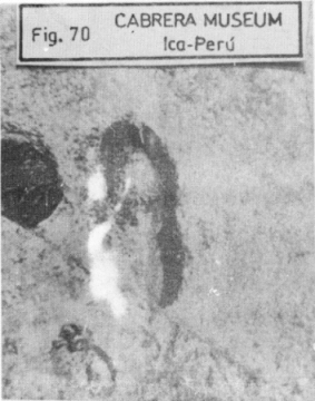
FIGURE 70, 71, 72, 73:
Testimonies of the softening of the rock due to the intense heat that affected
the Earth in the distant past.
FIGURE 70: The footprints of a man wearing some sort of shoe and of an
unidentified animal, on rock in Quenco, Cusco.
Seventy kilometers northeast of
Line,
Peru, in a place called Huandoval, there is a large round stone - much like the
round stones of Ica that the gliptolithic humanity used to make their stone
etchings - that has human footprints on it (Fig. 71).
In many of the gliptoliths the etched drawings are sometimes erased in certain
parts as if, after being drawn, these stones had acquired a different shape.
This can only be explained if it is hypothesized that the stones were softened
after being drawn on, and then collided among themselves. The precataclysmic
situation that softened, the Earth's crust and the following cataclysm were the
cause of this characteristic in the gliptoliths (See the back of the surgeon in
the gliptolith of Fig. 57).
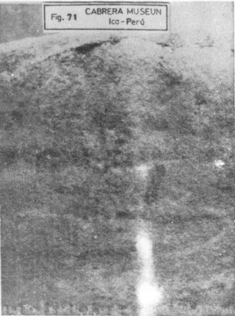
FIGURE 71: Round stone in
Huandoval - 70 kilometers to the northeast of Lima - that shows the footprints
of two feet.
In the Plaza de Armas of Cusco, Peru,
in front of the headquarters of the university of San Antonio Abad, there is a
large stone in which the huge footprint of an animal may be seen (Fig.
72). This footprint could only be from one of those colossal and
presently extinct animals known as dinosaurs. This stone demonstrates that
dinosaurs existed in the region of Peru and that this footprint, like the others
mentioned, could only have been left when the rock was softened due to intense
heat.
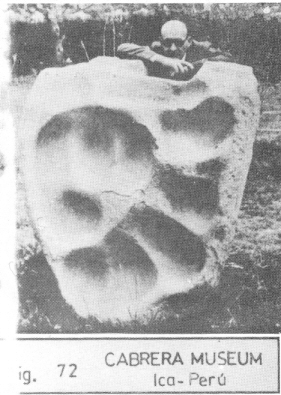
FIGURE 72: On a large stone in
Cusco what is known as the "Dinosaur's step".
In
Texas, in
the United States, there is a rock floor where the footprints of dinosaurs can
be seen, making up the floor of a walkway (Fig. 73).
These reveal that the intense heat that softened the rock was a phenomenon that
occurred throughout the planet.
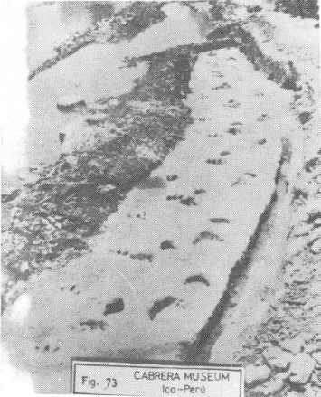
FIGURE 73: Footprints of a
dinosaur path on the rock floor of Texas, U.S.A.
Taking the above facts into
consideration, the following conclusion is reached: if man and animal left their
footprints fortuitously on the stone when it was softened by heat and humidity,
intelligent man, that saw this special condition of the rock, undoubtedly, took
advantage of it to leave intelligible messages etched in it. This allows me to
affirm that the Engraved Stones of Ica or gliptoliths were etched during this
precataclysmic period in order to send messages to the future to safeguard
against the loss of all the knowledge that had been accumulated in the cataclysm
that would take place.
-----------------------
Footnotes:
(37) I use the word Megapolis for the
big gatherings of reflexive and scientific human beings. It is of my
understanding that these men used to live in the Megapolis with different kinds
of men dedicated to the various activities related to the life in the planet.
(38) The alticamellus was a mammiferous
that lived, according to Paleontology, 13 billion years ago in the Tertiary
period. It is the equivalent to the present camel from the desert. They were
adapted to high temperatures with restricted hydrological resources. The
alticamellus on the stone shows us – graphically - the thermo-critical situation
shown by the planet. The average temperature had been increased up to such a
point that zoological life was only possible for conditioned species.
(39) Confront "El origen de los
primeros seres humanos". In Cuentos, mitos y leyendas
del
antiguo Peru. Compiled by Jose Maria Arguedas and Francisco Izquierdo Rios.
Ministerio de Educacion (Board of Education)
Lima,
1947.